For a long time, I've wanted to do a product review of Microsoft MapPoint, a geographical analysis and mapping tool, but I didn't have a database large enough to make it interesting. As I sat stroking my chin in puzzlement, it dawned on me--I'd like to know where the businesses with iSeries machines are. So, as a former MC Press Online insider, I cashed in a favor and got permission to run the MC Mag Online subscriber database through Microsoft MapPoint 2002. Privacy buffs, fear not, for in order to preserve privacy, I asked for only the city, state, and zip code for each customer. The data is now several months old, but in this case, we're only interested in relative data anyway, so we can compare locations against each other. Doing so reveals some interesting results, as you will see.
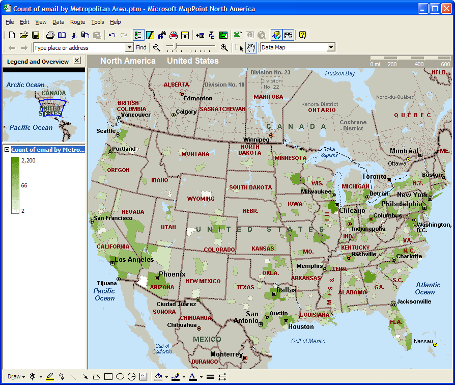
I wanted to see if MapPoint 2002 could show where subscribers are located, and as such, give a rough idea of where the iSeries shops are concentrated. For this review, I used MapPoint 2002 North America. A European version is also available. The results of pouring subscriber data into MapPoint are shown in Figure 1, which shows subscriber counts by U.S. metropolitan area. The darker circles represent more density. As you can see, Chicago has the largest count of subscribers, and that's where a lot of you are from. Chicago is an iSeries hotbed. Other top spots include the Los Angeles, Atlanta, Dallas, and Minneapolis/Rochester areas. The entire Eastern seaboard (from New York on down to Washington, D.C.) has a high density of subscribers as well. And as you can see, there are lots of you scattered across the country.

Figure 1: The green shaded areas represent MC Mag Online subscribers by metropolitan area in the United States. (Click images to enlarge.)
Note that there are large parts of the country that don't have any subscribers. This isn't too surprising, considering that the iSeries is generally geared for larger businesses and industry. Very small businesses are more likely to use PC-based hardware, and in remote portions of our country, that's all there is.
MapPoint 2002 Features
So, what can MapPoint do for you? From my perspective, it serves two useful purposes: mapping/directions/route planning (in the manner of MapQuest, Expedia, Yahoo! Maps, and many others) and showing business data geographically. The functions supporting the mapping/directions/route planning in MapPoint 2002 are quite good, and for those who need this type of tool, MapPoint seems worthy of checking out. But my primary interest is data, which is what MapPoint shines at.
If you want or need to see your data geographically, MapPoint 2002 can be a big help. It has a number of interesting features to help view your data from a geographic perspective. For example, you can group your data into territories. You can save the maps as Web pages, making it possible to use MapPoint to create an automatically updated Web site by linking to a data source with current data.
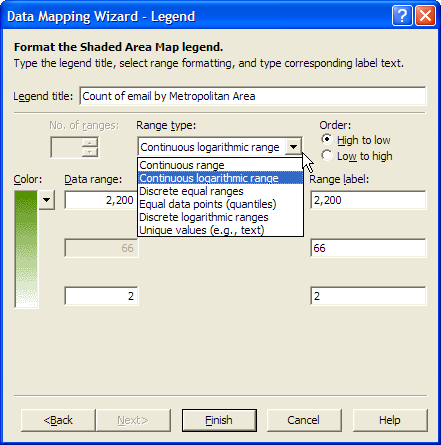
MapPoint offers many different types of charts and lots of options to slice the data. For example, as shown in Figure 2, you can change the way the data is shaded using the Data Mapping Wizard. In this case, using equal data points caused data to be grouped into quantiles, revealing how the data is distributed.

Figure 2: Choosing different range types helps you visualize your geographic data in different ways.
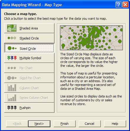
As shown in Figure 3, you have a number of options for displaying data based on volume. Figure 1 is done as a "Shaded Area" map. Other options include shaded or sized circles, and, if you have series data, a pie or column chart. As you change map types, the map is automatically recalculated, and you can see the results. With the proper hardware and data set size, you should be able to quickly move through the different views of your data.

Figure 3: Data can be projected onto the map using several different methods.
Importing iSeries Data into MapPoint
MapPoint can connect to a few different types of databases, although the list is far from extensive. Direct import formats include Excel, Access, Outlook, text files, Microsoft Data Link, and "pushpin" files from Expedia Streets & Trips 2000. While the list isn't extensive, it should be enough for most. Comma-separated values (CSV) are an old standby, and MapPoint supports Microsoft Data Link files as well, which opens up a number of connection options. Instead of adding the overhead of all that, I chose the ubiquitous CSV file type, which is easy to export from the iSeries with the CPYTOIMPF command (or by using the iSeries Access data transfer function). If you use the CPYTOIMPF command, one easy way to do it would be to first create the file in the IFS and then either navigate to the IFS (using Windows Explorer, for example) and import the file or copy the file to your local machine and import it from there.
With MapPoint, like Microsoft Access, you have the ability to import data or to link to it. If you import it, the data becomes local and separated from the source data, and processing speed is up to the local machine. If you link to your data, it is retrieved from the source each time, so you're sure to have the latest data for your maps. You may also benefit from the faster processing of "server" systems, but network performance will be a factor as well, so only you can determine which works best for your application.
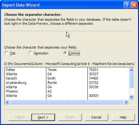
For this example, I'll import a file. Importing a CSV file is done by stepping though the panels of the Import Data Wizard (Figure 4). The basic CSV options are present, including the ability to accept tabs, semicolons, or commas as delimiters and the ability to specify the first row as containing field names.

Figure 4: CSV data can be imported via the Import Data Wizard.
Is MapPoint a Necessary Part of the Journey?
MapPoint lists for around $250. It's a great tool for trip and route planning. It also lets you slice and dice your data and shows it to you geographically, but it may be just another way of looking at something you already know. Whether or not it's worth the price depends on how you can benefit from it. Most of us already have existing reports ("Sales by Region", etc.) that provide target geographic areas. However, some people work best visually, and perhaps looking at things from a different perspective could lead to profitable inspirations that could easily be worth the price and time invested. If you're interested in trying MapPoint but are still on the fence, you may want to order the 60-day trial for $9.95.
Signing Off
Well, this is my last article as the Microsoft Computing columnist for MC Mag Online. I'm becoming a small business owner, and as such, I will be much too busy to continue writing, at least for the time being. You guys will be stoked to learn that Chris Peters will be taking over the column, so you can look forward to some good stuff-- Chris is a good guy and an excellent Microsoft resource!
Brian Singleton, former editor of Midrange Computing magazine, is an information systems consultant and future CPA. He can be reached at www.adscpa.com.


 Business users want new applications now. Market and regulatory pressures require faster application updates and delivery into production. Your IBM i developers may be approaching retirement, and you see no sure way to fill their positions with experienced developers. In addition, you may be caught between maintaining your existing applications and the uncertainty of moving to something new.
 IT managers hoping to find new IBM i talent are discovering that the pool of experienced RPG programmers and operators or administrators with intimate knowledge of the operating system and the applications that run on it is small. This begs the question: How will you manage the platform that supports such a big part of your business? This guide offers strategies and software suggestions to help you plan IT staffing and resources and smooth the transition after your AS/400 talent retires. Read on to learn:
LATEST COMMENTS
MC Press Online